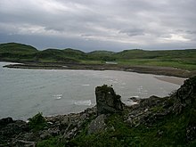
Sandaig Bay
A bay in Lochaber, ScotlandSandaig Bay is a coastal embayment, on a chord of 2.04 kilometres, on a 194° orientation, located on the northwestern end of the sea loch, Loch Nevis, facing the Sound of Sleat. The bay is within the western end of the Knoydart peninsula, in the Lochaber district in the historical county of Inverness-shire on the north west coast of Scotland.
Read article
Top Questions
AI generatedMore questions
Nearby Places

Mallaig
Scottish Highland port

Inverie
Human settlement in Scotland

Airor
Human settlement in Scotland

Mallaig railway station
Railway station in the Scottish Highlands
The Rough Bounds

Inverie Bay
Sea loch bay in NM

Loch an Nostarie
Freshwater loch

Mallaig Lifeboat Station
RNLI Lifeboat station in the Highlands, Scotland


